I’ve been wanting to do the Monomoy paddle for a few years. Last year I think it got canceled due to weather. This year I made the 120 miles commute from my house and I wasn’t disappointed.
We launched on a beautiful day as the air cleared of the morning mist. (Actually it was fog but I’m doing the writing so I’ll call it what I want.) The put in was some random seeming location near Chatham light. MAB and I were entertained by the directions Mike provided. They were detailed and we made no wrong turns.
Before we left we were all reminded of the guidelines regarding observing marine mammals. We had only paddled out a few miles and the sightings began. Before we knew it seals were popping up all around us observing us! As a group, we basically stopped paddling and just drifted. These seals weren’t the Sea Dogs (Harbor Seals) that we see in Newport mid-winter. They were much larger Gray Seals whose scientific name translates to "hook nosed pig of the sea". Clearly they hadn’t read the Marine Mammals Act because they were much closer than 100 yards and making some of us a bit nervous! They would typically pop up behind us and we’d hear their snorting breath. It was very satisfying to know that they were as interested in seeing us as we were them.
After about 20 minutes of seal observation we continued to paddle in the protection of South Beach towards Monomoy Island. There was very little agreement between the charts, the satellite photos, and what we were observing in front of us. The sands here are constantly shifting. At one point I was pushing my kayak along with my hands on the sand and the sand was liquid in nature. I assume something about the size and smoothness of the sand allows it to almost flow like water.
As we approached the break in the dunes out to the ocean we discussed whether to have lunch in the protected zone or pass through and have lunch on the ocean side. The relatively flat paddle so far had many of us wanting for a little excitement. We could see a small surf as we rounded the corner and thought lunch on the ocean would be fun. But as we continued it was obvious that what we were observing was the third break. There were two more bars with progressively larger waves breaking on the second and growling on the third. The outgoing flow kept us moving and gave us little time to select the best path through the surf zone. There were also various skill levels paddling so the more experienced kept an eye on the others as we passed. At one point I watched a paddler being lifted diagonally up a wave that was starting to become top heavy. I expected a capsize and headed in that direction unable to see the paddler on the other side of the wave which was easily standing up to about 4 feet in that area. About 10 seconds later I could see the top blade of her paddle and I knew she was still going. Great job. As most of the group gathered on the far side of the bar we realized that a few paddlers were missing. It became clear that Joe was helping a capsized paddler and Mike was standing by to help as needed. A few minutes passed and it became clear that Joe was not going to get him back in the boat in the surf. Some quick coaching was given and we all headed back in. The less experienced were directed towards the beach. A few went to the north side which was probably the safer side. The rest went south which was the livelier side with the surf breaking square onto the beach. Two of us headed to help Joe.
When we arrived Joe had given up on getting the paddler in the boat and had determined it was time to get him to the beach. He asked me to put him on my bow and paddle him in. It was a rescue I had never practiced. Joe was tiring and had been recovering from a bum shoulder so I wanted to help but I knew the gentleman I was with in a sit-on-top was more comfortable in the surf than I was. (It was his surf boat.) And his bow looked a heck of a lot more buoyant than my Ellesmere’s. I hesitated and tried to communicate that to Joe. Joe was determined to use me simply because he knew my abilities. He quickly changed plans and put the paddler on his own bow and had me recover the paddle and hook on to the wayward boat.
Knowing that the boat was far less important than a person, I took my time to wait for Joe to clear the area and the surf to settle a bit before hooking up to the boat. I didn’t want to surf into them and once a wave catches you there’s not much you can do but ride it. Then I had no idea what to do with the paddle. I tossed it in the cockpit but was uncertain as to whether it would stay there. I hooked to the deck line and began paddling toward shore. The load from the boat in tow varied if it was pulling on the back of a wave or surfing down the face. Just as I was preparing to ride a wave into the beach I felt the load release on my tow rope. I thought that my tow belt had just rotated around my waist. But as I looked behind me the boat was free. Mike was watching and thought I had set it free deliberately so it wouldn’t surf itself into me. Actually, the deck line had snapped. I hooked up again to the bow toggle and continued my mission. As I gathered up the boat on the beach I could see that everyone had made it safely to shore or was paddling inside the break. With time to let my focus wander, I could see three seals frolicking in the breaking waves watching the rescue and us fumbling land mammals trying to play in their element! I felt sure they were laughing at us all.
Safe and sound on the beach we all enjoyed lunch and the warm sun. We were entertained by some motor boaters who had filled their motor’s water pump with the Chatham sands and seemed clueless as to what to do with the boat and the motor. Some of us helped them drag their boat against the current into calmer waters. As lunch ended a few of went back out to try our hands in the surf. The surf had died down considerably from before lunch. Presumably related to the level and the flow of the tide.
The paddle back was relaxing. The tide had receded and there was a lot more sand to be seen (and avoided). As we passed through the “seal zone” we were visited by fewer seals but one in particular was far braver and more inquisitive than all the others. He would pop up very close to the boat and hang out at the surface for an extended amount of time.
At the launch I tried a roll but it was not to be this day. Linda rescued me (she does that a lot). We loaded our boats on the cars and headed off to dinner. But the adventure was not over yet. As we pulled into the parking lot at the restaurant one of us had a blown out radiator hose. A successful search for an open auto parts store on a Saturday evening was performed at the dinner table with the miracle of the cell phone. Another rewarding day on the water. 9/16/06
Saturday, September 16, 2006

Friday, September 01, 2006
Boston Harbor Islands, Part 2 (AKA Gilligan's Island)
This time the plans were for a Friday night camp out on Lovells Island in Boston Harbor. But any plans included frequent checks on Hurricane Ernesto. All week I checked the forecast. Each morning the forecast for Saturday was reasonable (10-20). Each evening it was an aggressive15-20, gusts to 30. So the plans were we'd go out Friday and adjust our plans based on the "real time" forecast. Mary Ann B., Marianne M., Joe A., Carole C., and Paul B. headed out with our boats fully loaded with food, tents, sleeping bags, dry clothes, and more food.  Our intention was to beat the first island ferry to Lovell and get the prime camping spot. As we approached the landing the ferry was arriving so Carole paddled her kayak half way up the beach, jumped out, ran down the landing and got to the ranger before anyone got off the ferry. It was a funny to watch her determination but it was a wasted effort because no one was on the boat!So we arranged to meet the ranger at the end of the island and jumped in our boats to rightfully claim our prime camping spot. (We might just have well been named Brewster!) The site had a great view of Boston... and the Deer Island Waste Treatment Plant (we had forgotten about that part). It was ours for the taking but one last check of the weather indicated that we probably should change our location to an inner harbor island (Bumpkin). The paddle to Lovells in a 10 knot breeze with opposing tide was already exciting enough with our loaded kayaks. The 20 knot beam sea predicted for Saturday morning in the unfamiliar Boston harbor environment was more that we felt comfortable with.We snacked on Lovell and waited for Carleen, Ray, Allison, and Bill L. to join us for a day paddle. The campers, with their boats still loaded, headed out with the day trippers towards Green Island. From there the day crew and Joe headed to The Graves light house. The rest of us went over to Outer Brewster. We made a feeble attempt to rock garden with our loaded boats but the weight made them far too slow to be comfortable. And a collision between a fully laden kayak and a rock was sure to do damage. We jumped out on the south side of the Island, tied our boats up so they wouldn't get away, and explored the rocky shoreline.
  We waited for a considerable time for the day trippers to return from Graves but only Joe returned! What happened to the rest of them? Apparently a camera was left on Green and the day crew returned to fetch it. Separated again, the campers and the day crew headed to meet at Boston Light. There we crossed the channel together, passed through the Gut, and bid them fair well. We arrived on Bumpkin and found a nice open spot on the water where we could drag our kayaks up onto the grass and fit our tents. The four "plastic" kayaks huddled together and "Woodie" slept near Joe. Apparently Joe had done this before and Woodie acted like a bureau beside his tent.
  The rest of us spread or so carefully packed equipment randomly around the camp site.Like any camping adventure, it didn't really mater where we were as long as we had a fire to play with. Shared food, pleasant conversation, and marshmallow cooking competition kept us amused.We woke up to a 15 knot breeze. Far more tame than predicted but it's steadiness was to make paddling a chore. Carole prepared eggs and home fries. We took a walk around the island and took a suite of the same photos with three different cameras. We lazily re-packed our boats in anticipation of meeting Eric and the crew from his Hingham paddle. The boat packing seemed easier Saturday morning. I think it was because the Hingham crew ate all our leftovers!
  We paddled Saturday with Eric and the Ricka paddle. We lunched together then separated as we headed back to our cars parked on Windmill point. We arrived mid afternoon, tired, but truly relaxed from our two day adventure and the dozen or so friends we had the opportunity to paddle with. And finally, unlike last time, the aprez-kayak restaurant choice was a success!
Photos courtesy of Joe A. 9/1/06
http://kayaktriping.blogspot.com/2006/09/whats-little-wind.html
is a link to Eric's discusion of the trip from the Day Trippers perspective.
 Our intention was to beat the first island ferry to Lovell and get the prime camping spot. As we approached the landing the ferry was arriving so Carole paddled her kayak half way up the beach, jumped out, ran down the landing and got to the ranger before anyone got off the ferry. It was a funny to watch her determination but it was a wasted effort because no one was on the boat!So we arranged to meet the ranger at the end of the island and jumped in our boats to rightfully claim our prime camping spot. (We might just have well been named Brewster!) The site had a great view of Boston... and the Deer Island Waste Treatment Plant (we had forgotten about that part). It was ours for the taking but one last check of the weather indicated that we probably should change our location to an inner harbor island (Bumpkin). The paddle to Lovells in a 10 knot breeze with opposing tide was already exciting enough with our loaded kayaks. The 20 knot beam sea predicted for Saturday morning in the unfamiliar Boston harbor environment was more that we felt comfortable with.We snacked on Lovell and waited for Carleen, Ray, Allison, and Bill L. to join us for a day paddle. The campers, with their boats still loaded, headed out with the day trippers towards Green Island. From there the day crew and Joe headed to The Graves light house. The rest of us went over to Outer Brewster. We made a feeble attempt to rock garden with our loaded boats but the weight made them far too slow to be comfortable. And a collision between a fully laden kayak and a rock was sure to do damage. We jumped out on the south side of the Island, tied our boats up so they wouldn't get away, and explored the rocky shoreline.
 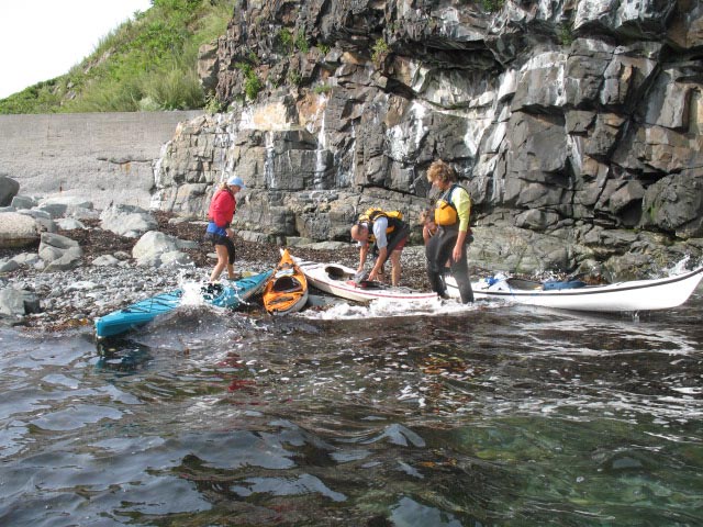 We waited for a considerable time for the day trippers to return from Graves but only Joe returned! What happened to the rest of them? Apparently a camera was left on Green and the day crew returned to fetch it. Separated again, the campers and the day crew headed to meet at Boston Light. There we crossed the channel together, passed through the Gut, and bid them fair well. We arrived on Bumpkin and found a nice open spot on the water where we could drag our kayaks up onto the grass and fit our tents. The four "plastic" kayaks huddled together and "Woodie" slept near Joe. Apparently Joe had done this before and Woodie acted like a bureau beside his tent.
  The rest of us spread or so carefully packed equipment randomly around the camp site.Like any camping adventure, it didn't really mater where we were as long as we had a fire to play with. Shared food, pleasant conversation, and marshmallow cooking competition kept us amused.We woke up to a 15 knot breeze. Far more tame than predicted but it's steadiness was to make paddling a chore. Carole prepared eggs and home fries. We took a walk around the island and took a suite of the same photos with three different cameras. We lazily re-packed our boats in anticipation of meeting Eric and the crew from his Hingham paddle. The boat packing seemed easier Saturday morning. I think it was because the Hingham crew ate all our leftovers!
 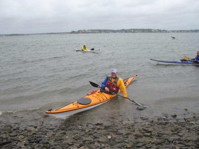 We paddled Saturday with Eric and the Ricka paddle. We lunched together then separated as we headed back to our cars parked on Windmill point. We arrived mid afternoon, tired, but truly relaxed from our two day adventure and the dozen or so friends we had the opportunity to paddle with. And finally, unlike last time, the aprez-kayak restaurant choice was a success!
Photos courtesy of Joe A. 9/1/06
http://kayaktriping.blogspot.com/2006/09/whats-little-wind.html
is a link to Eric's discusion of the trip from the Day Trippers perspective.
Thursday, August 10, 2006
Boston Harbor Islands, Part 1
“It was all Carole’s idea” is the way I would describe it. With the end of summer approaching she was looking for a little adventure beyond the confines of Narragansett Bay. Her suggestion was Cape Anne but I (Paul B.) countered with Boston Harbor Outer Islands because of the option of staying inside Hull if the weather was worse then we expected when we arrived. The day we chose had perfect tides for leaving the Hull Gut and then for carrying us back later in the day. So with little more than that and a bunch of maps for a plan Mary Ann B. and I arrived at the Hull boat ramp. As we waited for Carole C. and Becka S. to arrive the conversation had already turned to “Gilligan’s Island” and the misadventures we might have as the day went on. MA’s part was obvious. If you know the hat I wear it was clear that I would be Giligan. C was assigned to Ginger and B was to be Mrs. Howell. And so after 2 or 3 cell phone calls from the RI contingent as to where the end of Hull was it was clear who would be assigned the maps and that the theme was appropriate. None of us had ever done this paddle before.
We launched our boats into a beautiful day with very light wind and comfortable temperatures. The pass through the gut was uneventful and we passed Boston light on the outgoing tide way too soon to be getting out of our boats. So Becka pointed to Shag rocks and announced that that was where we were headed (Becka now known as “Lovey” and playing the part with a fine British accent which somehow seemed appropriate.)
As we arrived at the rocks we were treated to clear views down 6-8 feet into undulating kelp and a bevy of passing stripped bass. Lovey and I started rock gardening passing back and forth through the rocks, followed by MA. I found a 30 ft passage that was barely the width of a kayak and again the three of us went through. C just watched presumably just waiting to scrape us up from the rocks. As I made my second, scratch free path through the skinny tunnel I could hear MA beginning to hoot it up. As I rounded the corner I was treated to the sight of B in her kayak levitating about 6 inches above the water with rocks supporting both ends of her kayak. This position was held for long enough that she was ready to get out of her kayak as MA and I went in to help. Finally another set of waves freed her bow and slid her safely into the sea right side up.
From here we headed to Outer Brewster Island. I announced that I though that the other side would be a better place to have lunch. My decree was challenged and after explaining that I always take a window seat when flying out of Logan I had to admit that I had no idea. But we went around to the other side just the same. We landed at dead low tide on seaweed coated rocks. A short climb to dry rocks placed us with a great view of The Graves Light House and the entertaining antics of the resident sea gulls. After a lunch punctuated with cookies provided by C it was mutually decided that we were headed to Graves.
As we approached Graves we were reminded about how powerful the ocean really is. The seas that I would describe as less than a foot in open water were unleashing amazing power on the rocks, the first thing they had found in 100’s of miles. More rock gardening occurred. The passages were alternately named the PB “Tunnel of love” or PB “Love Canal”. Although the Graves looked fairly close from OBI the view back indicated just how far out we were.
Next stop was Green Island. We explored a decaying barge from our boats and then MA and B headed through another Love Canal. As I entered the passage all the water drained out from under my boat. This wasn’t too bad but I knew all the water was soon to return. As expected (and feared) I managed to surf my boat into the rock wall as the surge returned. Once inside inspection showed a chunk of gel coat removed from my bow and the fact that we were in a lagoon and had to pass back out the same route of demise. With favorable timing we all exited safely.
Now it was C’s turn to decree “We’re going to explore this Island”. We landed our boats on a small gravel beach and I took the opportunity to pop off my shoes to let my feet dry a bit. (A fateful decision.) As we walked the rocks it was clear that we really wanted to be on the main part of the island that was a short wade across a shallow channel. Somewhat because we hadn’t pulled the boats up too far, somewhat because I didn’t want to get wet, and somewhat because I didn’t want to wade in bare feet, I let the three ladies go across and I stayed back. I climbed the rocks a bit and they “shopped” the island for beach glass and shells. After an indeterminate amount of time I turned around to see two of our boats floating away. I ran over to the two remaining boats, jumped in B’s boat paddled out to clip into the first boat (mine)with my tow belt. I simply wrapped my rope around the toggle of the second boat only to have it come loose again. Meanwhile the girls looked over and said “Oh look, Paul is bringing the boats over to us and one got away”. “Should we go help him?” “No, let him be, he’s got a little project going!”
From Green I. we touched a number of islands back to Great Brewster I. Now it was my turn to decree “We’re going to Lovell I. to check out the camp grounds.” We passed along some neat wave action along GB spit where waves approached each other from each side forming little Geysers where they collided. We landed on Lovell and found that there are some great tent sites with awesome views of the city.
After over 14 miles of what was a wonderfully fun day of paddling we arrived back at the launch. But the adventure was not over yet. Dinner provided more mayhem than the paddle…. But I guess that’s a story for a different forum. 8/16/06
We launched our boats into a beautiful day with very light wind and comfortable temperatures. The pass through the gut was uneventful and we passed Boston light on the outgoing tide way too soon to be getting out of our boats. So Becka pointed to Shag rocks and announced that that was where we were headed (Becka now known as “Lovey” and playing the part with a fine British accent which somehow seemed appropriate.)
As we arrived at the rocks we were treated to clear views down 6-8 feet into undulating kelp and a bevy of passing stripped bass. Lovey and I started rock gardening passing back and forth through the rocks, followed by MA. I found a 30 ft passage that was barely the width of a kayak and again the three of us went through. C just watched presumably just waiting to scrape us up from the rocks. As I made my second, scratch free path through the skinny tunnel I could hear MA beginning to hoot it up. As I rounded the corner I was treated to the sight of B in her kayak levitating about 6 inches above the water with rocks supporting both ends of her kayak. This position was held for long enough that she was ready to get out of her kayak as MA and I went in to help. Finally another set of waves freed her bow and slid her safely into the sea right side up.
From here we headed to Outer Brewster Island. I announced that I though that the other side would be a better place to have lunch. My decree was challenged and after explaining that I always take a window seat when flying out of Logan I had to admit that I had no idea. But we went around to the other side just the same. We landed at dead low tide on seaweed coated rocks. A short climb to dry rocks placed us with a great view of The Graves Light House and the entertaining antics of the resident sea gulls. After a lunch punctuated with cookies provided by C it was mutually decided that we were headed to Graves.
As we approached Graves we were reminded about how powerful the ocean really is. The seas that I would describe as less than a foot in open water were unleashing amazing power on the rocks, the first thing they had found in 100’s of miles. More rock gardening occurred. The passages were alternately named the PB “Tunnel of love” or PB “Love Canal”. Although the Graves looked fairly close from OBI the view back indicated just how far out we were.
Next stop was Green Island. We explored a decaying barge from our boats and then MA and B headed through another Love Canal. As I entered the passage all the water drained out from under my boat. This wasn’t too bad but I knew all the water was soon to return. As expected (and feared) I managed to surf my boat into the rock wall as the surge returned. Once inside inspection showed a chunk of gel coat removed from my bow and the fact that we were in a lagoon and had to pass back out the same route of demise. With favorable timing we all exited safely.
Now it was C’s turn to decree “We’re going to explore this Island”. We landed our boats on a small gravel beach and I took the opportunity to pop off my shoes to let my feet dry a bit. (A fateful decision.) As we walked the rocks it was clear that we really wanted to be on the main part of the island that was a short wade across a shallow channel. Somewhat because we hadn’t pulled the boats up too far, somewhat because I didn’t want to get wet, and somewhat because I didn’t want to wade in bare feet, I let the three ladies go across and I stayed back. I climbed the rocks a bit and they “shopped” the island for beach glass and shells. After an indeterminate amount of time I turned around to see two of our boats floating away. I ran over to the two remaining boats, jumped in B’s boat paddled out to clip into the first boat (mine)with my tow belt. I simply wrapped my rope around the toggle of the second boat only to have it come loose again. Meanwhile the girls looked over and said “Oh look, Paul is bringing the boats over to us and one got away”. “Should we go help him?” “No, let him be, he’s got a little project going!”
From Green I. we touched a number of islands back to Great Brewster I. Now it was my turn to decree “We’re going to Lovell I. to check out the camp grounds.” We passed along some neat wave action along GB spit where waves approached each other from each side forming little Geysers where they collided. We landed on Lovell and found that there are some great tent sites with awesome views of the city.
After over 14 miles of what was a wonderfully fun day of paddling we arrived back at the launch. But the adventure was not over yet. Dinner provided more mayhem than the paddle…. But I guess that’s a story for a different forum. 8/16/06
Subscribe to:
Posts (Atom)